Learning Experience/Unit
Mapping My Spot in History
Subject
English Language Arts (2005), Social Studies, The Arts (1996)
Grade Levels
Intermediate, 6th Grade, 7th Grade, 8th Grade
Assessment
Students will be assessed based on the contents of portfolios that include the following:
- Personal dictionaries of architectural and cartographic terms
- Real estate ads
- Copies of collages representing the blocks where they live
- Letters to students in the year 2103
Personal Dictionary RubricReal Estate Ad RubricMy Block Collage RubricLetter Rubric
Learning Context/ Introduction
Students often think of history as tattered documents, worn photographs, and musty books, all of which have little or no relevance to their lives. Maps provide an often-overlooked source of information and a new and compelling perspective on the past. By revising the work of early twentieth century cartographers, and understanding the underlying motivation for their work, students can claim a historical spot of their own.
In an era of great mobility and immigration of families from other countries, students' homes are a haven and an anchor in a neighborhood. By learning about architectural styles and periods and identifying the best features of their homes, students begin to see their homes as places of value in relation to the broader community portrayed on the panoramic map of their town.
Students create their town’s history for coming generations and place themselves on the map in a literal as well as figurative sense, by producing portions of an updated version of an early twentieth century panoramic map from the American Memory collections. To complete this project, they gather information from a variety of primary sources, including the early twentieth century map, photographs, drawings, and site visits. Each student contributes to the revised map by creating a contemporary map of her or his block.
Duration
3-4 weeks
Objectives
Students will:
- Become familiar with panoramic and other kinds of maps as primary sources of historical information and become proficient at observing and interpreting maps;
- build a working vocabulary of architectural and cartographic terms;
- appreciate their own role in affecting and making history; and
- contribute to a revised panoramic map of their town.
Procedure
The procedure for this learning experience is composed of the following parts:
Part I: Investigating Maps - Students analyze several different types of maps and begin to create a dictionary of cartographic and architectural terms and definitions.
Part II: Investigating Community - Students analyze a historical map of their community and identify recognizable sites. They learn to differentiate between architectural styles and date the homes on their block and place their own homes in an historical context.
Part III: Real Estate Advertising - Students connect with the original purpose of panoramic maps-attracting prospective residents, businesses, and investors to the town-as they look at their own homes through the eyes of potential buyers or renters. They examine real estate advertisements and create advertisements for their own homes.
Part IV: Creating Personal Maps - Students create a collage by drawing the homes and other structures on their blocks. After the blocks are completed and joined, students write letters to future children in their community explaining the mapping project.
Part I
Investigating Maps
Prior to the lesson:
- Assemble a variety of maps.
- political
- physical
- weather
- contour
- road
- panoramic
- historical
- globes
- Search the American Memory map collections for examples and information that will be useful in helping students to interpret what they see. Check your school library for a variety of maps, or search the Internet for "printable maps."
Procedure
- Students identify and examine the different kinds of maps. Lead students in an in-depth discussion of panoramic maps--their history, vocabulary, and purpose--as a form of persuasive medium designed to "sell" a city or town. Visit the Panoramic Maps collection and read about the maps and their creators.
- Students compare and contrast the various maps in terms of scale, point of view, detail, date, purpose, and uses. Students record their detailed observations on the Observing Primary Sources sheet.
- Introduce students to Map Vocabulary. This vocabulary list is just a beginning. Terms may be added or deleted as needed. Students also need to know architectural terms. The about.com web site has a good Architecture Glossary.
- Throughout the entire lesson, students will record all new cartographic and architectural terms and definitions. See two examples of dictionary entries in a personal dictionary: Example 1 and Example 2. Assess the dictionaries with the Personal Dictionary Rubric.
- At the end of each step in the lesson, ask, "What words have we learned?" Add these words to a Word Wall (grouping of word posters). Print each word in type as large as 125 points on 8 1/2" x 11" paper.
Part II
Investigating Community
Procedure
- Arrange for time in the computer lab.
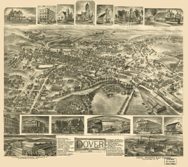
- Students investigate an historical map of their community, such as the Dover, New Jersey 1903 panoramic map and locate sites that have personal meaning for them (the streets on which they live, schools, parks, and other places they frequent).
- Note: If computer lab is not available, print out the map for classroom use. Click on the map for a larger image and scroll to bottom of that page to download MrSID viewer and the panoramic map. For more information, see the Viewing and Listening to American Memory Collections page.
- Students collect data about their homes. They can determine the architectural style of their houses using the What Style is Your Home? form. Additional information about house styles can be found at House Styles from about.com. Note: The local tax assessor's office can provide information on the age of the homes. Send a written request explaining the purpose and listing all house numbers and streets. Allow sufficient time for a response.
- Students take photographs, digital or snapshot, of their homes. Snapshots may be scanned and saved to a diskette.
- Students should look at the block on which they live. Have each student complete a graphic organizer about his or her block. Show students a completed example of the organizer.
- For record-keeping purposes, keep a master file of 3 x 5" index cards with the following information:
- First and last name of student
- Address
- City or town
- Nearest important building or landmark
- Digital picture number or filename
- Year in which house was built or approximate age if year cannot be determined
Part III
Real Estate Advertising
Procedure
- Collect a variety of home real estate ads that include photographs from a local newspaper. Saturday and Sunday newspaper editions usually provide the best selection. Enlarge and duplicate enough copies for each student to have three or four different ads. Ask students to do the following:
- Note the kind of information given in each ad;
- observe the layout of the ad and print size for each type of information;
- interpret abbreviations;
- determine what kind of person might be a potential buyer for each home; and
- look at the asking price.
- Next, have student's access owners.com, or you may present similar material as a lecture/note-taking activity. At the owners.com site, students should:
- go to GUIDANCE TOOLS,
- go to ARTICLE AND REFERENCE LIBRARY
- go to "WRITING A GOOD REAL ESTATE AD"
- return to GUIDANCE TOOLS,
- click "AD WRITING TIPS"
- click "AD WRITING TIPS: LANGUAGE AND ABBREVIATIONS"
- Invite a real estate agent to explain how to compose an effective ad.
- Students apply what they have learned about home styles and advertising to create real estate ads for their own homes. Ads should include digital photos and descriptive text highlighting the positive characteristics of their homes. Use the Real Estate Ad Rubric as a guide.
Part IV
Creating Personal Maps
Procedure
- Students can learn the basics of perspective drawing under the direction of the art teacher. The art teacher can provide templates of common local architectural styles. Students may use these templates or create their own drawings of the buildings on the blocks where they live. See sample home drawings.
- Students create a collage that represents their blocks. Students paste the buildings to a paper backing in the correct position and add trees, streets, and other features, as needed. (At this point, the drawings are not yet joined with other blocks and are larger than they will appear in the final product.) Use the "My Block" Collage Rubric as a guide.
- Photocopy the collages, adjusting the size as necessary, to fit the size of the finished map.
- Students write to children who live in their community in the year 2103. The letters should:
- Explain the project;
- explain how they feel about working on a project that is one hundred years old;
- explain how working on the map has made them a part of history;
- explain how they have made history by working on the map; and
- invite the recipient to make a 2103 edition of the map.
- Also use the Letter Rubric as a guide.
Resources/Materials
American Memory
Additional sources
- Architecture Glossary from about.com
- House Styles from about.com
- Schoonmaker and Laurie. Images of America: Dover. Charleston, S.C.: Arcadia Publishing, 1999.
- Local tax assessor's office
- Local daily newspapers
- Historical and geographical sources such as globes, atlases, local and state maps, photographs, and drawings (not all need be current)
- Templates of local architectural styles
Extension
Students continue to draw grid sections of the contemporary map. Section by section they gather data about structures erected since 1903. Students create drawings of those structures and affix them to the new map.
Further extension activities:
- Students examine the panoramic photo of their town's main street from the American Memory collection Taking the Long View: Panoramic Photographs, 1851-1991. They identify buildings that are still standing and those that are not. In journals, they speculate on the activities of the people in the photo. They create their own contemporary panoramic photo of the same vista. Finally, they make a videotape of a student walking down the main street narrating what she or he sees compared with that in the turn of the century photo.
- Students examine antique local postcards from the collection of a community member. They match the postcard images to buildings on the map. In their journals, they respond to the messages written by the senders of the postcards.
- Students observe and respond in journals to photos of children from the American Memory collection, Touring Turn-of-the-Century America: Photographs from the Detroit Publishing Company, 1880-1920. Students compare and contrast photos of children from 1900-10 to those of today.
- Students make PowerPoint presentations to a variety of audiences, explaining their work as cartographers.
Duration
3 - 4 weeks
Author
Judy Klement and Elizabeth Park
Source
Reproduced from the Library of Congress web site for teachers. Original lesson plan created as part of the Library of Congress American Memory Fellows Program.